Amsterdam is linked to the sea by the North Sea Canal, a wide ship canal, built in 1875 and later widened. The canal cut through the dunes, and it ended at a sea lock, protected by breakwaters. There was nothing else at first, just dunes, but a town grew up around the locks: IJmuiden. Later the locks were expanded, a fishery port was built, and a railway, and then a steelworks (1918), and later more port industry. Although it has 32 000 inhabitants, and port traffic, the railway to IJmuiden was closed in 1983.
Even without freight traffic, re-opening of the line seems feasible. The 5-km alignment is intact: partly used as cycle path, part road, and part busway. It connects at Santpoort Noord, to the existing line to Haarlem and Amsterdam. The line could carry a regional metro service to Amsterdam (28 km), or a shuttle service to Harlem with six intermediate stops (11 km).
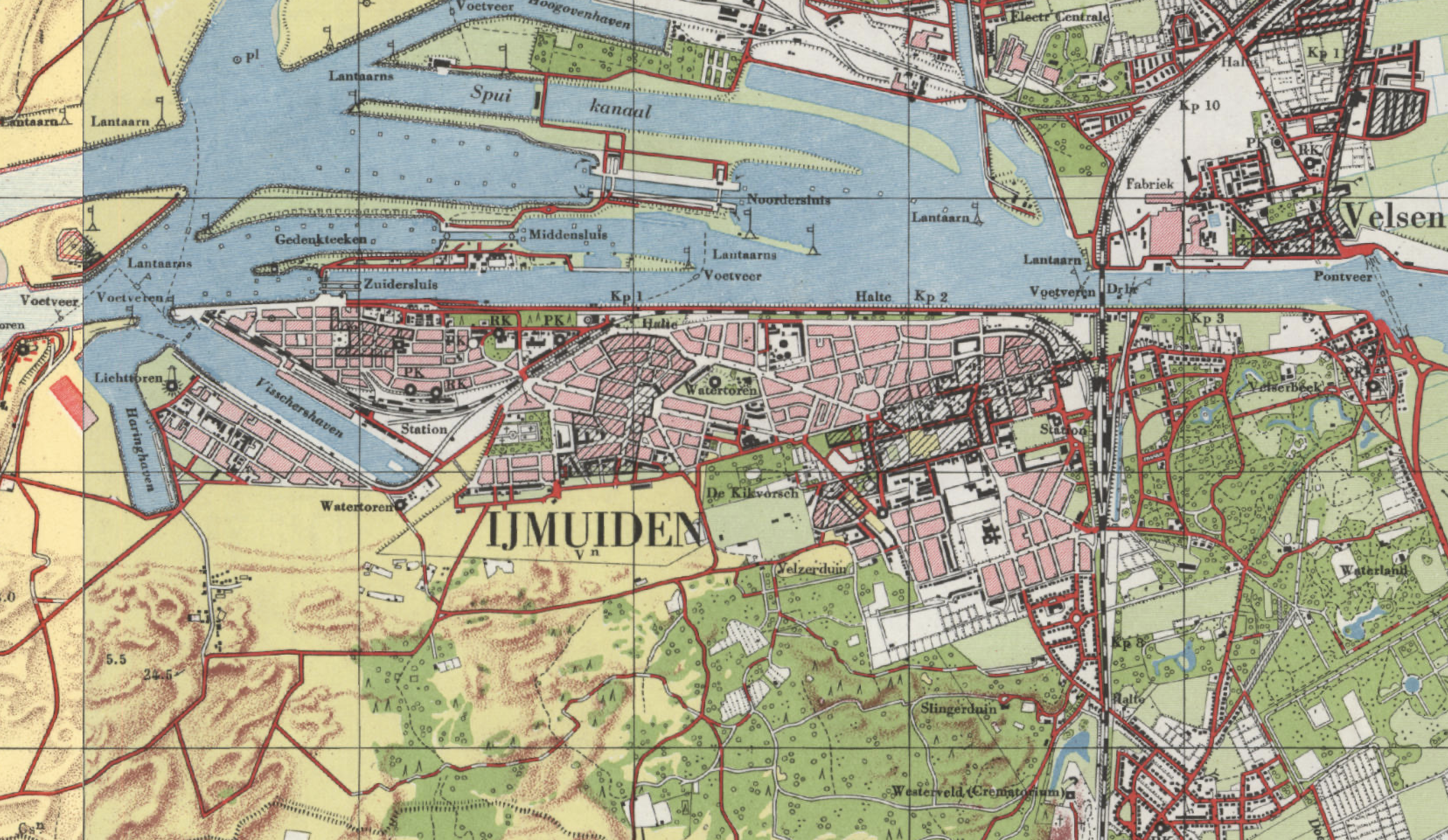
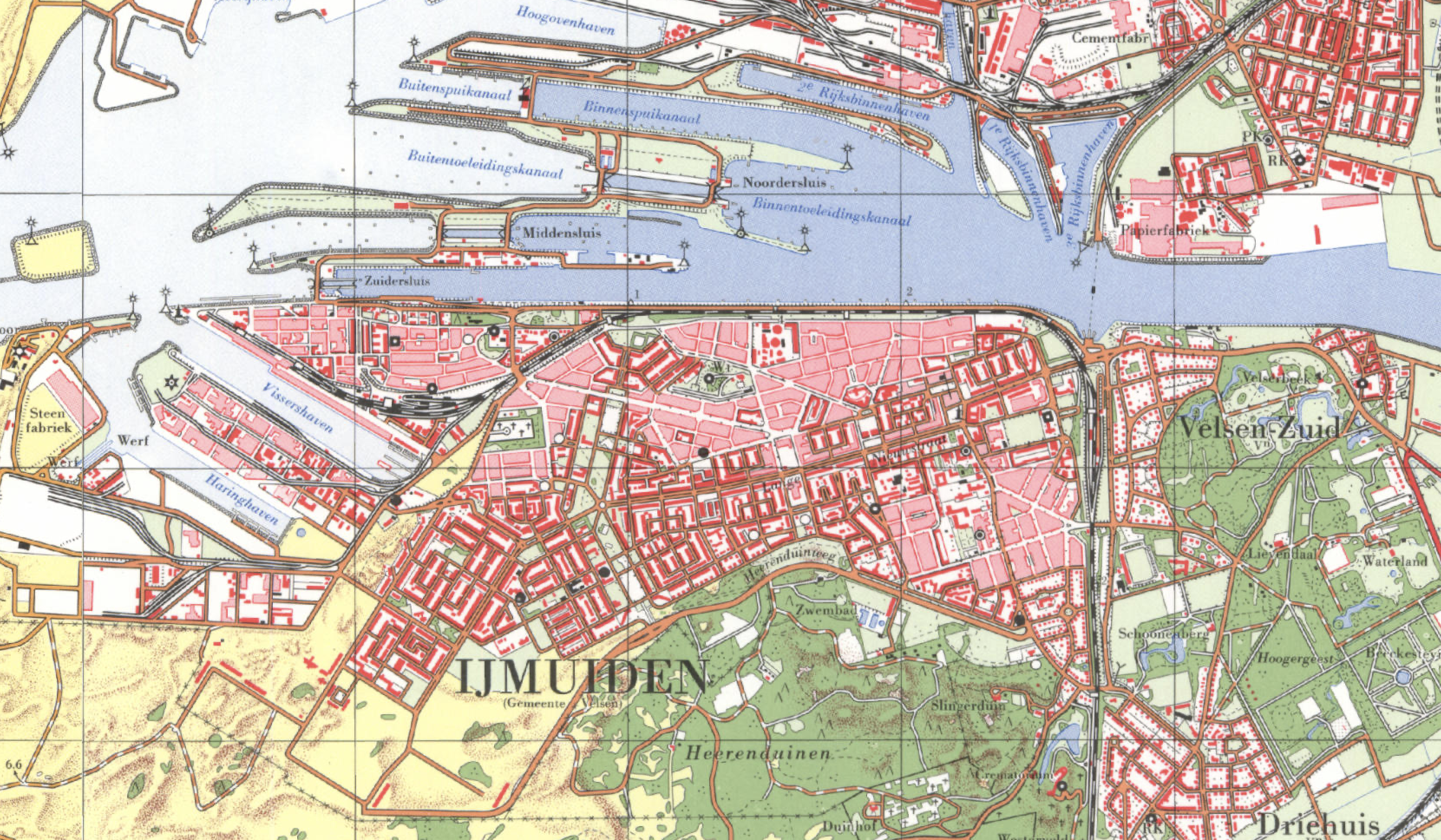
The base maps used here are are the municipality maps by Jan-Willem van Aalst at Wikipedia.
The former railways in the area
Historically, all infrastructure in this region is oriented north-south, parallel to the coast. The first railway in the Netherlands (1839-1843) ran from Amsterdam to Harlem, and then turned south to The Hague. In 1867, a similar northern route was opened: parallel to the coast, from Haarlem north to Den Helder (Spoorlijn Haarlem – Uitgeest). When a shorter route to Amsterdam was opened, this became a secondary line, between Haarlem and Alkmaar.
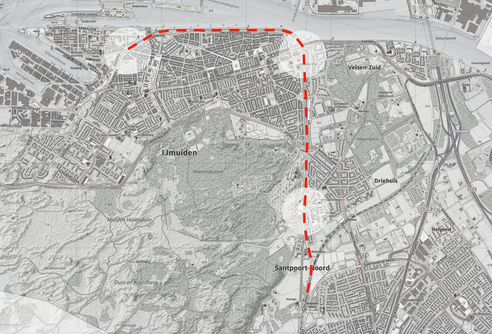
All the north-south infrastructure in the region was cut, when the North Sea Canal was opened in 1875. The original canal was relatively narrow, and the Haarlem – Alkmaar line crossed it by a swing bridge. As IJmuiden grew, a 6 km branch line was built (1883), running along the south bank of the North Sea Canal. In 1957, the swing bridge was replaced by a tunnel, further east. The branch line to IJmuiden then diverged at Santpoort-Noord Station, and that alignment remained in use, until the closure in 1983. (Dutch wiki: Santpoort-Noord – IJmuiden )
The present state of the alignment
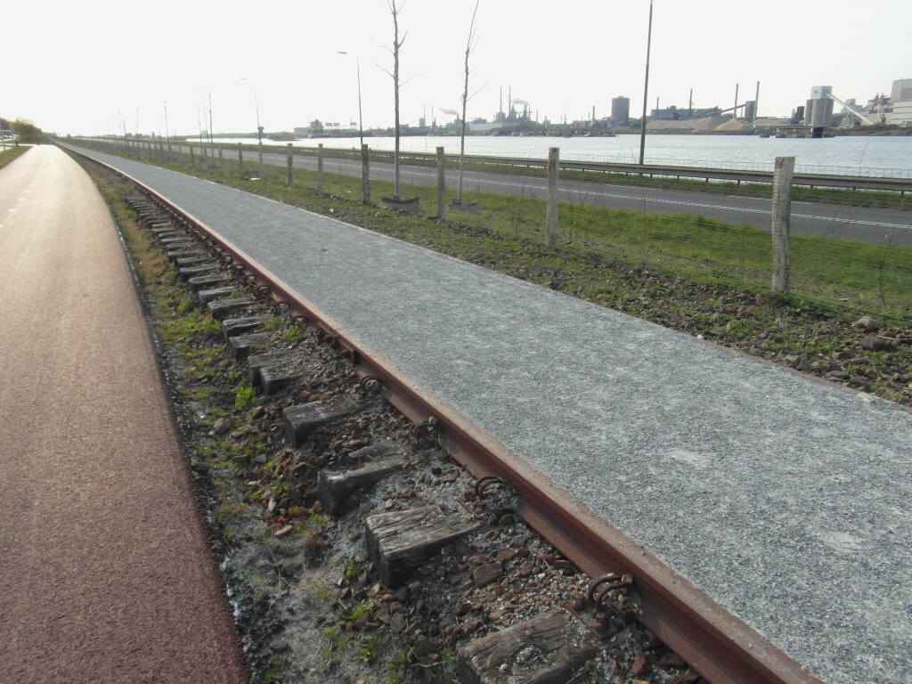
Santpoort-Noord Station was ‘moved sideways’ in 1957, to make room for a junction with the new line under the North Sea Canal. The line to IJmuiden diverged just north of this station, and rejoins its older alignment about 1100 m further. From there it runs 2 km north, to the former IJmuiden Oost station, located at Tiberiusplein. There were two intermediate halts, at Westerveld Cemetery, and om the old main road into IJmuiden (Zeeweg). This section has been converted to a busway.
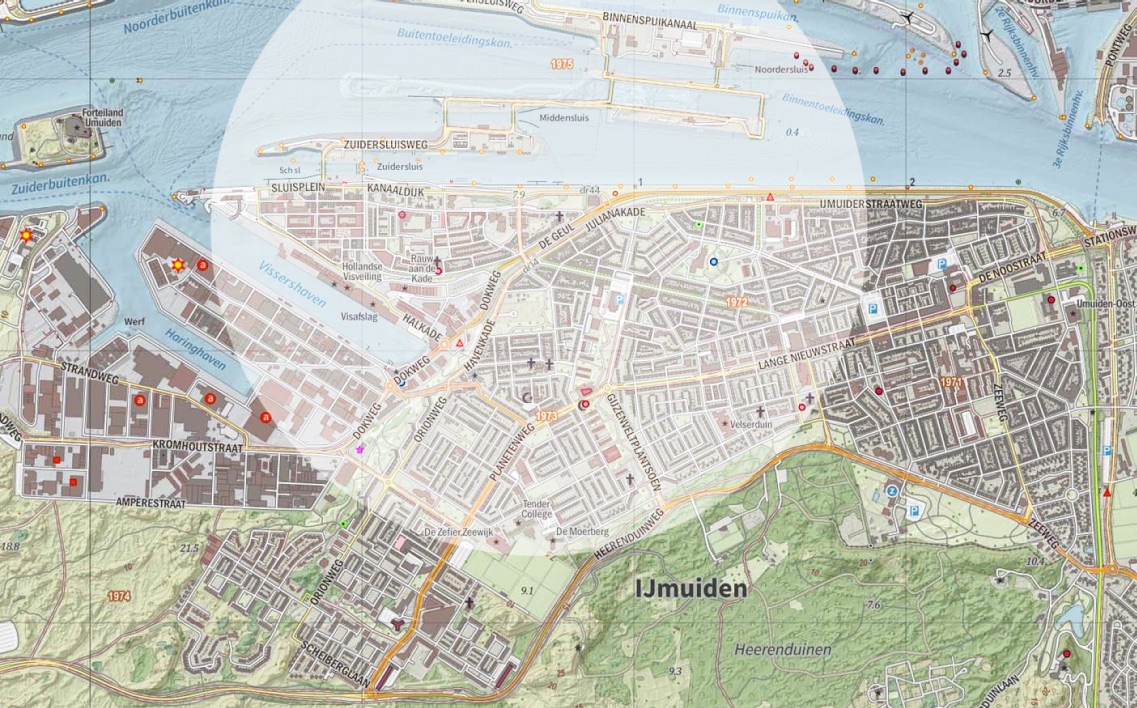
The first station in IJmuiden was located just before the former swing bridge: the older map here (via topotijdreis.nl) shows the IJmuiden line diverging, just after this station. The line then ran west alongside the canal, to the last station, near the sea locks, in the oldest part of IJmuiden. The maps show, roughly, the situation in the 1950’s, and in the 1960’s, after demolition of the swing bridge.
Upgrading the regional context
It would be possible to re-open the IJmuiden line as it was, when closed in 1983 – with restoration of double track, and electrification. However, re-opening would make more sense, in the context of upgrades to other infrastructure in the region. Aside from the environmental benefits, something has changed since 1983: the population is growing. Officially the municipality of Velsen will grow by 10% until 2050, but latent demand for housing in the Greater Amsterdam region could imply much faster growth. All suggested improvements are justifiable on their own, but provide synergy with the re-opening of the IJmuiden line.
Firstly, the Haarlem – Amsterdam rail line – the oldest in the country – could get more capacity, and higher line speeds. The first step would be the long-planned relocation of the line in western Amsterdam, from Sloterdijk to Halfweg.
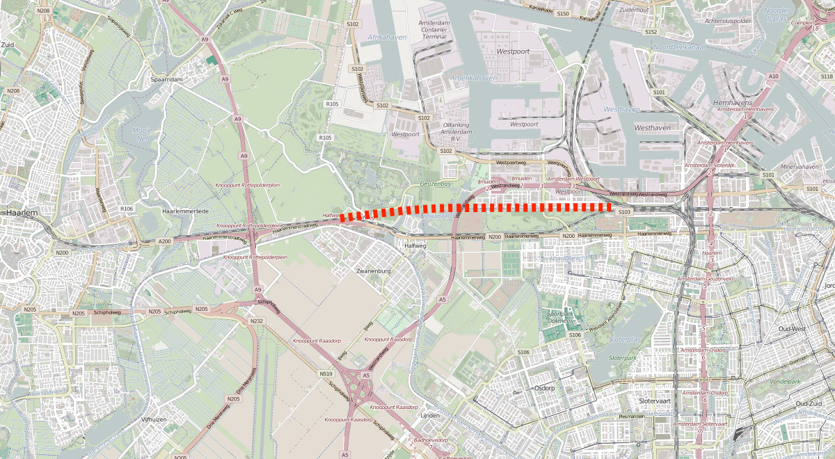
The new 5-km alignment should have four tracks, for better separation of InterCity and local services, preferably with additional capacity between Sloterdijk and Amsterdam Centraal Station. The extra capacity is a precondition for a regional metro service. In Haarlem itself, additional capacity is required between Spaarnwoude Station and the main station. The existing double track between Spaarnwoude and Halfweg, with no intermediate stations, might be sufficient.
Upgrading the Haarlem – Amsterdam line will permit either a regional metro service IJmuiden – Amsterdam, or better interchange with more frequent InterCity trains at Haarlem. In both cases, journey time should be under 30 minutes.
The second relevant upgrade is for the Haarlem – Beverwijk – Alkmaar line, which any IJmuiden service will use south of Santpoort. Line speeds are relatively low, and there are several level crossings in semi-urban neighbourhoods. A minimal upgrade would raise the line speed between Haarlem and Beverwijk – to 120 km/h, and preferably 130 km/h. A grade-separated junction at Uitgeest is a precondition for higher frequencies, on the Haarlem – Alkmaar and Amsterdam – Alkmaar routes. It would also allow a fast service Alkmaar – Haarlem, stopping at Uitgeest, the logical terminus for a regional metro service from Amsterdam. To improve capacity at Haarlem Station, a new grade-separated junction might be needed on the western side.
The utility of the line from Haarlem to Beverwijk can be improved, by better connections to northern Haarlem. The main problem here is the barrier effect of the Haarlem western ring road, the N208. The existing road could be relocated in a cut-and-cover tunnel, preferably including the section through Overveen. That is a complex project, with 3 km of tunnel in an urban area. A simpler option is to close the western ring road, and restore the road layout of about 1960. Closure is feasible, because there are now alternative routes, on the eastern side of Haarlem. Either way, several new east-west connections could be built or restored, between northern Haarlem and Bloemendaal, with new cycle tunnels under the rail line.
That could be combined with an additional station in Bloemendaal, and relocation of the existing station, to the north. The additional station would serve southern Bloemendaal, and northern Haarlem, south of the Zaanenlaan. The relocated station would serve northern Bloemendaal, and Haarlem north of the Zaanenlaan. With these stations, and higher frequencies, the line between Haarlem Station and Santpoort-Noord could serve a a regional metro for the northern half of Haarlem. Although these improvements are not in IJmuiden itself, they would improve the utility of the re-opened line.
With the increased capacity, the Alkmaar – Haarlem fast service could run all day, and not only in peak hours. With an additional stop at Santpoort-Noord, it would provide interchange with the re-opened IJmuiden line, for travel between IJmuiden and Beverwijk / Heemskerk. The re-opened line from IJmuiden would also connect at Haarlem, with the existing InterCity services to Leiden and Rotterdam.
A re-opened line
The existing station at Santpoort-Noord has sufficient capacity. for a limited additional service to IJmuiden. Higher frequencies would require a grade-separated junction there, probably with an additional platform. From Santpoort-Noord to the North Sea Canal, the present busway would essentially be reconverted to a double-track railway. A new station would be built on the site of the former Westerveld halt, serving the village of Driehuis. An underpass would replace the former level crossing here. At present Driehuis has 3 000 inhabitants, but it could house 5 000.
In IJmuiden, there would be a new station on the site of the former IJmuiden Oost station, at Tiberiusplein. Until the Second World War, this was a peripheral location, but IJmuiden later expanded eastwards, and it is now 400 m from the central shopping street, and the Town Hall. With limited demolition, the main street (Lange Nieuwstraat) can be extended to the station, and the station area redeveloped. The new station would be the main interchange with bus services inside IJmuiden, and should also be accessible from the ferry landing (Pontplein), for the ferry to Velsen-Noord and Beverwijk. The station needs an eastern exit, toward the centre, and a northern exit, toward the ferry. There is already a bus stop on the northern side, served by bus routes from the east (present 74 and 382 routes). Bus routes from the south can be re-routed to this stop, via Minister van Houtenlaan: they would pass the station and the ferry on their way to the centre. On the map, the circle is 1200 m radius, about 20 minutes walk allowing for the street pattern.
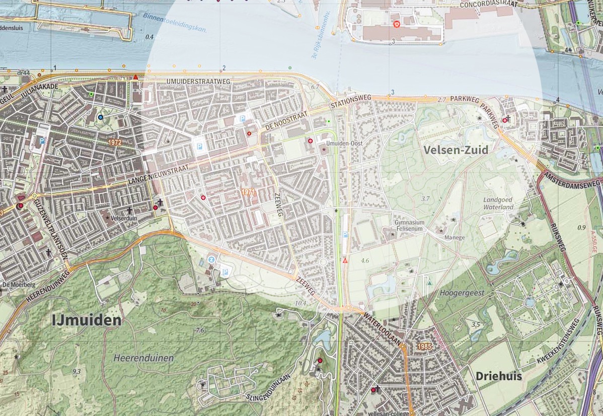
Although the re-opened line could terminate at Tiberiusplein, it is more logical to re-open the entire line. That requires an additional 2400 m of restored track. Most of it can exactly follow the old alignment, but there is a sharp curve between Tiberiusplein and the canal bank. It could be realigned by shifting the new platforms slightly to the west, at a slight angle to the former platforms. The old line then ran along the canal bank, next to the road to the sea locks. There is no housing, or indeed any building, on the north side, so no crossings are needed on this section. Very little work is needed here – in fact the old rails are still there, converted to a footpath.
As it approaches the sea locks, the line turns away from the canal bank: one cycle crossing needs an underpass here. The line then runs in cutting toward the dock basins, and the oldest part of IJmuiden. The cutting was necessary, because the railway cuts through the dunes here. There is no point in re-opening the old station, which has disappeared anyway: a new station would adjoin the only bridge over the cutting, Julianabrug. It can serve the eastern half of IJmuiden, while still directly adjoining the old town, now mostly redeveloped. The station layout should permit later restoration of a rail track to the port area.
Train services
The re-opened line Haarlem – IJmuiden would carry trains at the same frequency as the line Haarlem – Beverwijk – Uitgeest, with alternating departures from Haarlem. At present there are two trains per hour, but that is insufficient for an urban-regional line. A 20-minute service, three trains per hour, is best on reopening. That implies a 10-minute service between Santpoort-Noord and Haarlem – reasonable after the suggested improvements on this section. Ultimately, with increasing population in the urban area, both lines could carry a 15-minute service, with 8 trains per hour south of Santpoort-Noord station.
Bus services
At present, four bus lines serve IJmuiden, all using different routes, and with different destinations. With a re-opened rail line, two or three would be sufficient. Six lines run north through northern Haarlem: four or five would be sufficient. The re-opened railway would be the main service between IJmuiden and Haarlem: the bus lines would connect to it.
The regional bus line (382) from Sloterdijk Station in Amsterdam, through the port zone, to IJmuiden, would retain its present route. One bus per hour runs to the beach at IJmuiden, and all of them in the weekend. The route to the beach can be shortened, and bus services timed to connect with trains at the new Tiberiusplein station.
The present bus line 74, through old IJmuiden and then through the motorway tunnel to Beverwijk, could be retained. In theory, a reopened rail line allows passengers from IJmuiden to reach Beverwijk with a change of train at Santpoort-Noord, but that is inconvenient if an additional bus transfer is required.
At present, bus line 3 from Haarlem to IJmuiden via Velserbroek, terminates in central IJmuiden. It would be re-routed to terminate at Santpoort-Noord, for transfer to IJmuiden and Beverwijk trains. With higher frequencies, and synchronised with train services, this line can also replace the present bus line 73.
The present ‘express’ bus line IJmuiden – Haarlem, bus 385, would operate in parallel with the reopened rail line, retaining its present terminus in southern IJmuiden (Dennekoplaan). It would revert to an urban bus line, synchronised with train departures at the new Tiberiusplein station. It would lose its route over the busway in Driehuis, and return to its original route on the main road there. (That would restore a stop at the existing Driehuis station, for trains to Beverwijk.)
The urban bus line 2 in Haarlem, would be diverted to pass the relocated Bloemendaal station, and would be extended to Santpoort Noord, replacing a section of bus line 481. In fact, with an additional station in Bloemendaal, and much higher train frequencies, most of the present line 481 could be abandoned. An alternative was proposed earlier at this blog: a new Haarlem ring line, using a new bus underpass in Bloemendaal, and serving four stations in Haarlem. It would incorporate the southern section of line 481, and also parts of lines 2, 4, 14, and 15.
The other north-south bus line in northern Haarlem, bus 14, can retain at least its present route there, and its transfer to local bus line 12.
On the north bank of the North Sea Canal, one or two bus lines in Beverwijk could start at the ferry landing. Restoration of rail services from Tiberiusplein, which adjoins the ferry landing on the southern side, would make this an option for travel south toward Santpoort, Bloemendaal, and Haarlem. It is however difficult, to synchronise ferry crossings with train and bus, because the ferry must wait for passing ships.
Conclusion
The re-opening of the railway to IJmuiden, a relatively simple project in itself, can best be approached as part of a general upgrade of public transport in the region Haarlem / IJmond, which has about 400 000 inhabitants.

Great article.
It would make sense to extend the train to the port immediately. There are daily ferry boats to/from New Castle (UK). A train connection could help to reduce the amount of planes here.
In theory, tracks could be re-instated right up to the quayside, about 50 m from the ferry itself. However, traditional ‘boat trains’ are difficult to fit between high-frequency urban and regional services, such as those proposed here. Modern ferries are focused on car and ro-ro traffic anyway. Perhaps this route retains more traditional ‘foot passengers’, but it might not be enough to justify a separate train.