From 2023 all posts will be in English. Older proposals for infrastructure entirely inside the Netherlands were in Dutch. Go to the category “In English” for all older English-language items.
Infrastructuur geheel binnen Nederland werd in het Nederlands beschreven, maar vanaf 2023 is alles in het Engels.
A new Danube rail bridge at Komárom was proposed here earlier, as part of a high-speed route from Vienna and Bratislava, to Budapest. Historically, there are two main lines from Vienna to Budapest: one south of the Danube via Győr, the other north of the river, via Bratislava and Nové Zámky. The earlier proposal here was to combine sections of both lines, with a new 40-km line from Komárom to Štúrovo, and a Danube bend cut-off line.
That combination is no longer relevant, because a new high-speed line from Győr to Budapest is planned, concentrating traffic south of the river. Nevertheless, a new bridge would be justified, with a Štúrovo cut-off line, creating a new inter-regional route toward the existing Danube bend line. (Maps from OpenStreetMap and OpenRailwayMap).
The rail junction and bridge at Komáron / Komárno (OpenRailwayMap)
The town of Komárno /Komárom on the Danube has been divided since the break-up of the Austro-Hungarian Empire. The north bank (Komárno) is in Slovakia, the south bank (Komárom) is in Hungary. Their combined population is about 55 000.
The main line from Vienna, via Győr (German: Raab), was originally known as the Wien-Raaber_Bahn. East of Győr, it runs alongside the Danube for about 15 km, passing through Komárom, with a station on the river bank. The line then turns south-east to Tatabánya, and enters Budapest from the west.
On the north bank, in Slovakia, Komárno station is the end of a secondary single-track route from Bratislava, (line 124A). There is another line to Nové Zámky, on the Bratislava – Budapest line.
Line 124A (OpenRailwayMap)
The existing railway bridge is west of the built-up area, and the route between the two stations is indirect. The bridge creates a north-south secondary route – from Nitra and Nové Zámky in Slovakia, to Székesfehérvár in Hungary. A new bridge would improve that route, but it requires about 5 km of new track, to allow trains from Székesfehérvár (line 5) to approach the new bridge from the west.
The new double-track bridge would take trains from Győr into the existing Komárno station (north bank), but not through the riverside station in Komáron (south bank). A new 3-km line would leave the line from Győr, at the egde of Komáron. It would first cross the main channel of the Danube, and then an island with low-density housing, and then a secondary channel. The line across the island would be on viaduct, but some demolition is unavoidable. On the north bank, the line would follow existing freight tracks to Komárno station.
The new bridge / viaduct
In Komárno, the new bridge viaduct probably requires closure of the existing east-west road viaduct, but it can be easily replaced by an underpass. This road (Slovakian highway 63/64) could also be relocated alongside the regional rail line from Bratislava, or outside the town, on a semi-circular bypass.
The new bridge would be justified on its own, but would also allow a new inter-regional route along the Danube. A new 35-km alignment to Štúrovo would start just outside Komárno, and would run parallel to the Danube, about 3 km north of the river. It would run through flat agricultural land, avoiding the villages, to join the existing main line from Nové Zámky (120A), about 5 km from Štúrovo station.
Approximate alignment, base map from OpenRailwayMap
Trains would continue on the existing main line along the Danube bend, to Nyugati station in Budapest. Since the new line is intended for an inter-regional service, trains would run from Győr to Komárno (40 km), from there to Štúrovo (about 40 km), and on to Budapest via Vác (about 80 km), a total route of 160 km.
A possible future option is an upgraded link from Vác toward Hatvan (Hungarian lines 71/77/78), connecting with the main line north-east from Budapest. In that case, the new route would bypass Budapest.
At Komárno, the new route crosses the existing north-south secondary route – from Nitra and Nové Zámky in Slovakia (lines 122C and 120B), to Székesfehérvár in Hungary (line 5). It would be logical to electrify and upgrade this route (about 150 km), in combination with the new east-west route. It is also logical to upgrade the line from Bratislava to Komárno, via Dunajská Streda, about 100 km long. The non-electrified line carries some commuter traffic into Bratislava, but east of Dunajská Streda it is a typical single track rural line, with very basic halts serving small villages.
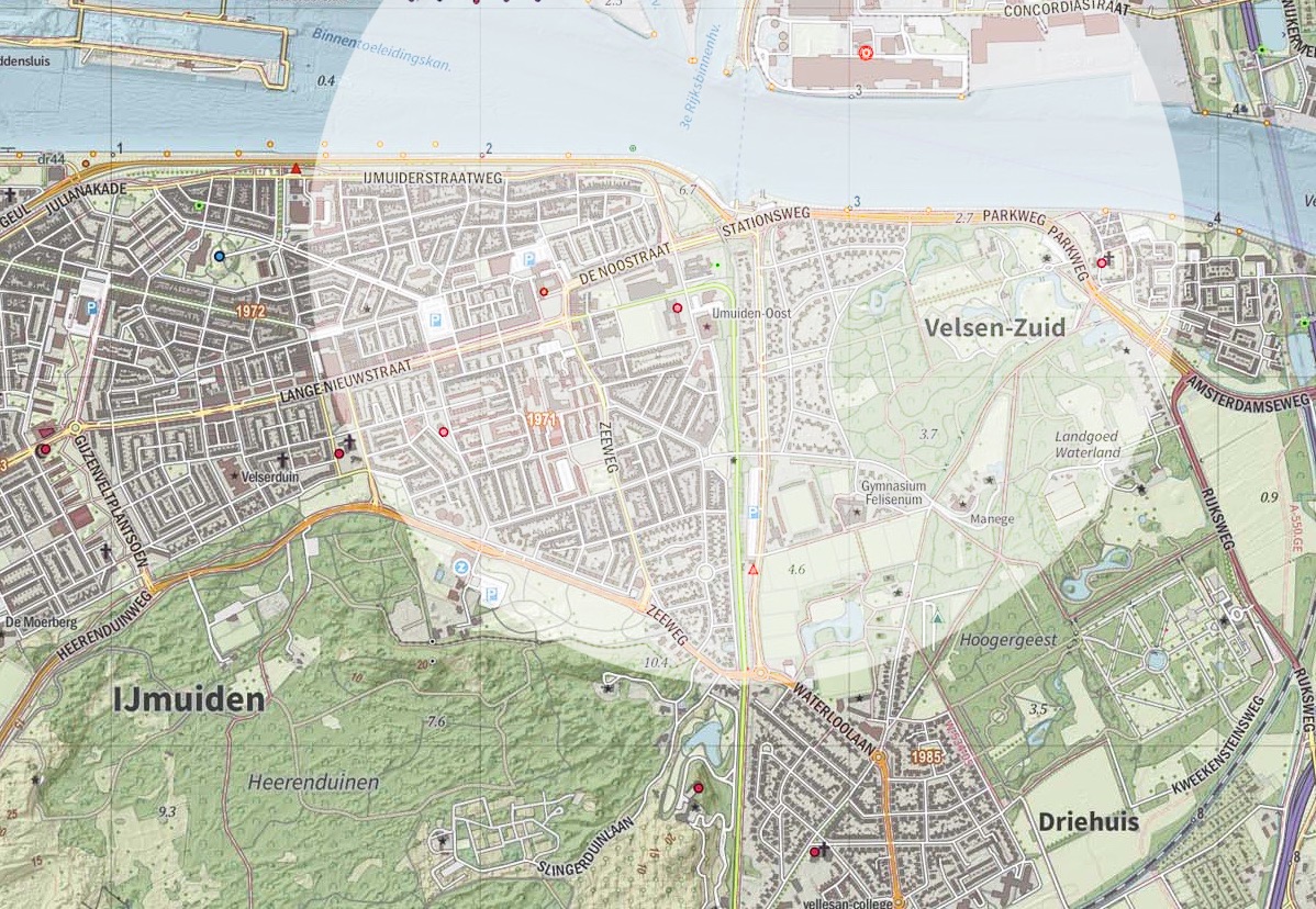
Amsterdam is linked to the sea by the North Sea Canal, a wide ship canal, built in 1875 and later widened. The canal cut through the dunes, and it ended at a sea lock, protected by breakwaters. There was nothing else at first, just dunes, but a town grew up around the locks: IJmuiden. Later the locks were expanded, a fishery port was built, and a railway, and then a steelworks (1918), and later more port industry. Although it has 32 000 inhabitants, and port traffic, the railway to IJmuiden was closed in 1983.
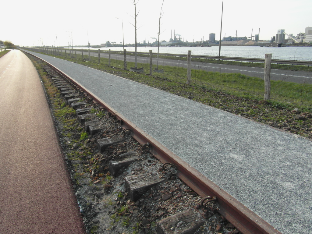
Even without freight traffic, re-opening of the line seems feasible. The 5-km alignment is intact: partly used as cycle path, part road, and part busway. It connects at Santpoort Noord, to the existing line to Haarlem and Amsterdam. The line could carry a regional metro service to Amsterdam (28 km), or a shuttle service to Harlem with six intermediate stops (11 km).
The base maps used here are are the municipality maps by Jan-Willem van Aalst at Wikipedia.
The former railways in the area
Historically, all infrastructure in this region is oriented north-south, parallel to the coast. The first railway in the Netherlands (1839-1843) ran from Amsterdam to Harlem, and then turned south to The Hague. In 1867, a similar northern route was opened: parallel to the coast, from Haarlem north to Den Helder (Spoorlijn Haarlem – Uitgeest). When a shorter route to Amsterdam was opened, this became a secondary line, between Haarlem and Alkmaar.
All the north-south infrastructure in the region was cut, when the North Sea Canal was opened in 1875. The original canal was relatively narrow, and the Haarlem – Alkmaar line crossed it by a swing bridge. As IJmuiden grew, a 6 km branch line was built (1883), running along the south bank of the North Sea Canal. In 1957, the swing bridge was replaced by a tunnel, further east. The branch line to IJmuiden then diverged at Santpoort-Noord Station, and that alignment remained in use, until the closure in 1983. (Dutch wiki: Santpoort-Noord – IJmuiden )
The present state of the alignment
Santpoort-Noord Station was ‘moved sideways’ in 1957, to make room for a junction with the new line under the North Sea Canal. The line to IJmuiden diverged just north of this station, and rejoins its older alignment about 1100 m further. From there it runs 2 km north, to the former IJmuiden Oost station, located at Tiberiusplein. There were two intermediate halts, at Westerveld Cemetery, and om the old main road into IJmuiden (Zeeweg). This section has been converted to a busway.
The first station in IJmuiden was located just before the former swing bridge: the older map here (via topotijdreis.nl) shows the IJmuiden line diverging, just after this station. The line then ran west alongside the canal, to the last station, near the sea locks, in the oldest part of IJmuiden. The maps show, roughly, the situation in the 1950’s, and in the 1960’s, after demolition of the swing bridge.
Upgrading the regional context
It would be possible to re-open the IJmuiden line as it was, when closed in 1983 – with restoration of double track, and electrification. However, re-opening would make more sense, in the context of upgrades to other infrastructure in the region. Aside from the environmental benefits, something has changed since 1983: the population is growing. Officially the municipality of Velsen will grow by 10% until 2050, but latent demand for housing in the Greater Amsterdam region could imply much faster growth. All suggested improvements are justifiable on their own, but provide synergy with the re-opening of the IJmuiden line.
Firstly, the Haarlem – Amsterdam rail line – the oldest in the country – could get more capacity, and higher line speeds. The first step would be the long-planned relocation of the line in western Amsterdam, from Sloterdijk to Halfweg.
The new 5-km alignment should have four tracks, for better separation of InterCity and local services, preferably with additional capacity between Sloterdijk and Amsterdam Centraal Station. The extra capacity is a precondition for a regional metro service. In Haarlem itself, additional capacity is required between Spaarnwoude Station and the main station. The existing double track between Spaarnwoude and Halfweg, with no intermediate stations, might be sufficient.
Upgrading the Haarlem – Amsterdam line will permit either a regional metro service IJmuiden – Amsterdam, or better interchange with more frequent InterCity trains at Haarlem. In both cases, journey time should be under 30 minutes.
The second relevant upgrade is for the Haarlem – Beverwijk – Alkmaar line, which any IJmuiden service will use south of Santpoort. Line speeds are relatively low, and there are several level crossings in semi-urban neighbourhoods. A minimal upgrade would raise the line speed between Haarlem and Beverwijk – to 120 km/h, and preferably 130 km/h. A grade-separated junction at Uitgeest is a precondition for higher frequencies, on the Haarlem – Alkmaar and Amsterdam – Alkmaar routes. It would also allow a fast service Alkmaar – Haarlem, stopping at Uitgeest, the logical terminus for a regional metro service from Amsterdam. To improve capacity at Haarlem Station, a new grade-separated junction might be needed on the western side.
The utility of the line from Haarlem to Beverwijk can be improved, by better connections to northern Haarlem. The main problem here is the barrier effect of the Haarlem western ring road, the N208. The existing road could be relocated in a cut-and-cover tunnel, preferably including the section through Overveen. That is a complex project, with 3 km of tunnel in an urban area. A simpler option is to close the western ring road, and restore the road layout of about 1960. Closure is feasible, because there are now alternative routes, on the eastern side of Haarlem. Either way, several new east-west connections could be built or restored, between northern Haarlem and Bloemendaal, with new cycle tunnels under the rail line.
That could be combined with an additional station in Bloemendaal, and relocation of the existing station, to the north. The additional station would serve southern Bloemendaal, and northern Haarlem, south of the Zaanenlaan. The relocated station would serve northern Bloemendaal, and Haarlem north of the Zaanenlaan. With these stations, and higher frequencies, the line between Haarlem Station and Santpoort-Noord could serve a a regional metro for the northern half of Haarlem. Although these improvements are not in IJmuiden itself, they would improve the utility of the re-opened line.
With the increased capacity, the Alkmaar – Haarlem fast service could run all day, and not only in peak hours. With an additional stop at Santpoort-Noord, it would provide interchange with the re-opened IJmuiden line, for travel between IJmuiden and Beverwijk / Heemskerk. The re-opened line from IJmuiden would also connect at Haarlem, with the existing InterCity services to Leiden and Rotterdam.
A re-opened line
The existing station at Santpoort-Noord has sufficient capacity. for a limited additional service to IJmuiden. Higher frequencies would require a grade-separated junction there, probably with an additional platform. From Santpoort-Noord to the North Sea Canal, the present busway would essentially be reconverted to a double-track railway. A new station would be built on the site of the former Westerveld halt, serving the village of Driehuis. An underpass would replace the former level crossing here. At present Driehuis has 3 000 inhabitants, but it could house 5 000.
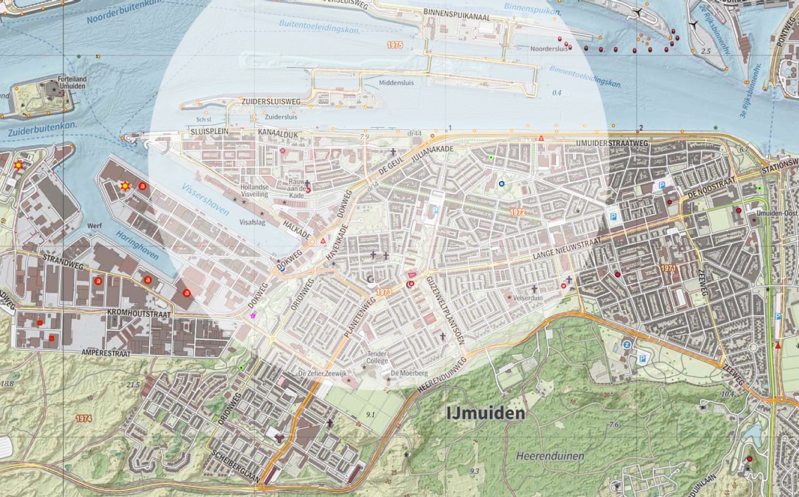
In IJmuiden, there would be a new station on the site of the former IJmuiden Oost station, at Tiberiusplein. Until the Second World War, this was a peripheral location, but IJmuiden later expanded eastwards, and it is now 400 m from the central shopping street, and the Town Hall. With limited demolition, the main street (Lange Nieuwstraat) can be extended to the station, and the station area redeveloped. The new station would be the main interchange with bus services inside IJmuiden, and should also be accessible from the ferry landing (Pontplein), for the ferry to Velsen-Noord and Beverwijk. The station needs an eastern exit, toward the centre, and a northern exit, toward the ferry. There is already a bus stop on the northern side, served by bus routes from the east (present 74 and 382 routes). Bus routes from the south can be re-routed to this stop, via Minister van Houtenlaan: they would pass the station and the ferry on their way to the centre. On the map, the circle is 1200 m radius, about 20 minutes walk allowing for the street pattern.
Although the re-opened line could terminate at Tiberiusplein, it is more logical to re-open the entire line. That requires an additional 2400 m of restored track. Most of it can exactly follow the old alignment, but there is a sharp curve between Tiberiusplein and the canal bank. It could be realigned by shifting the new platforms slightly to the west, at a slight angle to the former platforms. The old line then ran along the canal bank, next to the road to the sea locks. There is no housing, or indeed any building, on the north side, so no crossings are needed on this section. Very little work is needed here – in fact the old rails are still there, converted to a footpath.
As it approaches the sea locks, the line turns away from the canal bank: one cycle crossing needs an underpass here. The line then runs in cutting toward the dock basins, and the oldest part of IJmuiden. The cutting was necessary, because the railway cuts through the dunes here. There is no point in re-opening the old station, which has disappeared anyway: a new station would adjoin the only bridge over the cutting, Julianabrug. It can serve the eastern half of IJmuiden, while still directly adjoining the old town, now mostly redeveloped. The station layout should permit later restoration of a rail track to the port area.
Train services
The re-opened line Haarlem – IJmuiden would carry trains at the same frequency as the line Haarlem – Beverwijk – Uitgeest, with alternating departures from Haarlem. At present there are two trains per hour, but that is insufficient for an urban-regional line. A 20-minute service, three trains per hour, is best on reopening. That implies a 10-minute service between Santpoort-Noord and Haarlem – reasonable after the suggested improvements on this section. Ultimately, with increasing population in the urban area, both lines could carry a 15-minute service, with 8 trains per hour south of Santpoort-Noord station.
Bus services
At present, four bus lines serve IJmuiden, all using different routes, and with different destinations. With a re-opened rail line, two or three would be sufficient. Six lines run north through northern Haarlem: four or five would be sufficient. The re-opened railway would be the main service between IJmuiden and Haarlem: the bus lines would connect to it.
The regional bus line (382) from Sloterdijk Station in Amsterdam, through the port zone, to IJmuiden, would retain its present route. One bus per hour runs to the beach at IJmuiden, and all of them in the weekend. The route to the beach can be shortened, and bus services timed to connect with trains at the new Tiberiusplein station.
The present bus line 74, through old IJmuiden and then through the motorway tunnel to Beverwijk, could be retained. In theory, a reopened rail line allows passengers from IJmuiden to reach Beverwijk with a change of train at Santpoort-Noord, but that is inconvenient if an additional bus transfer is required.
At present, bus line 3 from Haarlem to IJmuiden via Velserbroek, terminates in central IJmuiden. It would be re-routed to terminate at Santpoort-Noord, for transfer to IJmuiden and Beverwijk trains. With higher frequencies, and synchronised with train services, this line can also replace the present bus line 73.
The present ‘express’ bus line IJmuiden – Haarlem, bus 385, would operate in parallel with the reopened rail line, retaining its present terminus in southern IJmuiden (Dennekoplaan). It would revert to an urban bus line, synchronised with train departures at the new Tiberiusplein station. It would lose its route over the busway in Driehuis, and return to its original route on the main road there. (That would restore a stop at the existing Driehuis station, for trains to Beverwijk.)
The urban bus line 2 in Haarlem, would be diverted to pass the relocated Bloemendaal station, and would be extended to Santpoort Noord, replacing a section of bus line 481. In fact, with an additional station in Bloemendaal, and much higher train frequencies, most of the present line 481 could be abandoned. An alternative was proposed earlier at this blog: a new Haarlem ring line, using a new bus underpass in Bloemendaal, and serving four stations in Haarlem. It would incorporate the southern section of line 481, and also parts of lines 2, 4, 14, and 15.
The other north-south bus line in northern Haarlem, bus 14, can retain at least its present route there, and its transfer to local bus line 12.
On the north bank of the North Sea Canal, one or two bus lines in Beverwijk could start at the ferry landing. Restoration of rail services from Tiberiusplein, which adjoins the ferry landing on the southern side, would make this an option for travel south toward Santpoort, Bloemendaal, and Haarlem. It is however difficult, to synchronise ferry crossings with train and bus, because the ferry must wait for passing ships.
Conclusion
The re-opening of the railway to IJmuiden, a relatively simple project in itself, can best be approached as part of a general upgrade of public transport in the region Haarlem / IJmond, which has about 400 000 inhabitants.
Proposals for a high-speed line between Novi Sad and Belgrade were posted here several years ago, when official plans were still incomplete. By now, the project is nearing completion, so there is no point in proposing an alternative alignment. Most of it follows the old line anyway. The official project is less ambitious than proposed here, with lower capacity and speeds, but still a significant improvement by Serbian standards. The line was always intended as part of a longer Budapest – Belgrade route, and work has started on the rest of that route, slowly. The line in Belgrade itself still needs improvement, and the new central station is still unfinished, despite decades of work.
There are possible alternative routes between Budapest and Novi Sad, but not between Novi Sad and Belgrade. Both cities are located at strategic river crossings, and the geography determined the alignment of the railway line in 1883.
Novi Sad is located north of the Fruška Gora mountain range. The range runs east-west, it is about 80 km long, and the Danube flows east-west to avoid it. The range has a ‘promontory’ on the northern side, and the Danube also bends around this promontory. Exactly at its northern point is the fortress of Petrovaradin, and on the opposite bank is the modern city of Novi Sad. The line from Budapest crosses the Danube here.
Originally the line used the shortest river crossing, and ran under the fortress in tunnel. From there, a straight line to Belgrade would require an additional tunnel under the Fruška Gora range, so the line turned south-east, to run alongside the Danube. The Novi Sad station, and the Danube rail bridge, were later moved further east, so the line no longer needs ridge tunnels. The old line had another tunnel further south, at Čortanovci. There, the line turns away from the river, and climbs up to the plateau south of the Fruška Gora. From there, it is almost a straight line to Zemun, at the edge of the Belgrade agglomeration.
The climb from the Danube at Čortanovci was the worst section of the old line, and it has been completely replaced, by a new viaduct/tunnel combination. The bridge at Novi Sad (Žeželjev Most) had been replaced earlier, after NATO bombing in 1999. South of Čortanovci, no major work was needed – just track renewal, and realignment of some curves. However, the most that Serbia can afford was a mixed-traffic double-track railway, designed for 200 km/h, at least on the middle section. The capacity is insufficient for true demand at a European level, and in some parts of Europe new high-speed lines are faster – 300 km/h.
The most significant realignment on the new line is through the Čortanovci tunnel, and on to Beška. The two images below show the variants proposed here earlier, and the line as built.
The earlier post also proposed a new tunnel from Zemun into western Belgrade (Novi Beograd). The line drops 15 m here, from the plateau to the Danube/Sava flood plains, and technically, a new tunnel is no problem, so it can be added later. However, the earlier proposal also assumed, that the HSL would terminate near the old Belgrade central station. That station has now been closed, and the site cleared for redevelopment. The only option is the badly-designed new central station at Prokop, Beograd Centar. It was planned decades ago, for internal Yugoslav train services, not for European high-speed networks.
In theory, Belgrade is the logical interchange station, between Central Europe and the Balkan Peninsula. That is irrelevant at present, because services south of Belgrade are so bad – infrequent trains, on low-speed single-track lines. A first step is the upgrading of the Belgrade to Niš line for 200 km/h, which is at the planning stage. But even if there were high-speed lines to Belgrade from all directions, Beograd Centar in its present form would be inadequate. That is a good reason to consider new bypass lines, such as this northern bypass proposed here earlier, from Batajnica to Smederevo.
That would not, however, solve the problem for trains into Belgrade itself. The approach lines to Beograd Centar are of low quality, and shared with local and regional services. There is no space to reverse trains, or store and service them, even for short periods. It might be possible to build additional terminal platforms on the north side of the station. That would also require extra approach tracks, including an additional bridge over the Sava.
And in theory, the low-grade lines into Beograd Centar could all be replaced. The existing tunnels could be duplicated, with additional fast tracks, and the older tunnels reserved for urban and regional services. Similarly, the bridge over Sava could be duplicated, and the life-expired Danube bridge replaced, by a new four-track version. The remaining surface approaches, inside the urban area, could be four-tracked – with some limited demolition. However, even with 100% adequate approach tracks, Beograd Centar would still be badly located, and have insufficient capacity.
New and upgraded rail lines, in the Baltic States and Kaliningrad Oblast, were proposed here earlier. The proposals were integrated with each other, and with the older network. One proposal was a north-south high-speed rail line, Kaunas – Riga – Tallinn. Since then, the official Rail Baltica project has finalised its alignment, and it is no longer relevant to propose an alternative. On the other hand, the war in Ukraine has altered the logic of the project. This post reconsiders the earlier proposals, with suggestions for improving the official alignment.
The capacity of the rail network in the region is limited, and passenger services are minimal. Rail transport has low priority in the three Baltic states, Lithuania, Latvia, and Estonia. They don’t cooperate with each other, or with their neighbours Belarus and Russia, and sometimes obstruct cross-border services. That was true long before the war. Lithuania was fined by the European Commission, for deliberately vandalising its own tracks, to block rail freight traffic into Latvia.
Not surprising, then, that the Rail Baltica project suffers from political hostility and interference. The alignment was determined by politics from the start, to avoid the Russian exclave Kaliningrad Oblast, which is the northern half of former East Prussia (Ostpreussen). Another example: the planned high-speed route from Vilnius to Warsaw makes a long detour. There was originally a direct line, but part of it is now in Belarus, and the three states can’t agree on re-opening. That would also require conversion to standard gauge, and the five states also can’t agree on gauge conversion policy. Another example: Latvia insisted on routing Rail Baltica through Riga airport, which will delay travellers between Estonia and Lithuania. These travellers will not be using Riga airport anyway, because all three countries protect their own national airports.
Then came the Ukraine war, which undermined the stated intention, to connect the Baltic states to the rest of the EU. The Rail Baltica alignment passes between Belarus and the Kaliningrad exclave. When it was planned, that was not a problem, because no hostile action was anticipated. But since then, Belarus has allowed Russia to use its territory for an invasion, and it might do that again. The unproblematic corridor from the EU to the Baltic states became a geopolitical flashpoint, the Suwałki Gap – a potential Russian corridor to Kaliningrad. Of course, that would mean war with Poland, but even if it was arranged peacefully, it would still destroy the concept of an internal EU link to the Baltic states.
For the present, it does not matter anyway, because the Polish government never took the line beyond Suwałki seriously. It was left as a single-track non-electrified route, with an indirect alignment via Šeštokai. In practice, the Polish refusal to improve the cross-border link, reduced Rail Baltica to a Kaunas – Riga – Tallinn line, with a few extra trains to Warsaw.
What kind of line?
The Rail Baltica project is not a standard high-speed line either. It will carry freight – serving three multimodal terminals, and the port east of Tallinn (Maardu). High-speed rail lines usually carry no freight, for good reasons. Slower freight trains obstruct fast trains, and they require an appropriate gradient, track, and structures.
The Rail Baltic line will also have regional stations – possibly almost 40. Again there are some examples in other countries, but conditions there are very different. Regional population densities in the Baltic States are very low, and declining even further.
Population decline, 2011-2020 (map from Reddit, no source was given).
That means that the regional stations will serve very few people, too few to fill the trains. Some of the proposed stations are clearly absurd – Pasraučiai village, with 34 inhabitants, Kaisma village (123 inhabitants), and Urge village (144 inhabitants). No specific funding is available for these stations, which will cost about €2 million each, and the small local governments cannot afford them. If there is no external source of funding, then most of these stations will never be built.
Regional trains are only possible, because planned frequencies are very low. Trains between the main stations – Tallinn, Pärnu, Riga, and Kaunas – will run every two hours. A high-speed line cannot be economic with such frequencies – the HSL-2 in England is designed for trains every three minutes. The frequency of regional trains is not fixed yet, but it cannot be very high either, or the trains will be almost empty. This suggests that the ‘high-speed’ Rail Baltica is in fact primarily for freight, which would make it unique among high-speed lines. These freight trains will run at 120 km/h, on a line built for 250 km/h.
Deficiencies of the planned alignment
Kaunas, Riga, and Tallinn are approximately aligned north-south, and the Rail Baltica line generally follows this route. The alignment is not a straight line at local level, however. It curves continuously, partly due to environmental constraints. Most of it does not follow existing infrastructure.
At three points, there are major flaws in the alignment north of Kaunas. After leaving the built-up area of Kaunas, the line turns toward Panevėžys (population 95 000). Instead of entering that city, however, it turns west, to pass though open country. A new north-south line through Panevėžys is difficult, because the existing rail line run east-west. So instead, there will be an interchange station, where the new line crosses the Šiauliai – Panevėžys line. Experience in France shows that stations in open fields don’t serve the surrounding region, even if they cross an existing rail line.
The design error at Panevėžys can be corrected, by adding a new standard gauge line into the center from the west. It can largely follow the bypass (A17), and join the existing alignment about 3 km east of the station. It is not a perfect solution, but it would allow a high-speed Panevėžys – Kaunas shuttle service.
The second major design flaw is the approach to Riga. In fact Rail Baltica has a double alignment at Riga, with a line through the city, and a bypass line. However, the new line through Riga will turn west, then follow the ring motorway to the airport, and then turn back toward the central station, alongside the existing Jūrmala line.
It is relatively easy to correct this design error, by building a link to the existing Jelgava – Riga alignment near Tiraine, with extra standard gauge tracks into Riga. The two routes join at Tornakalns, close to the main station. The new link alignment would be about 15-20 km long, with about 8 km alongside existing tracks.
North of Riga station, the planned alignment could be improved by building new standard gauge tracks, alongside the exiting line through Garkalne. This alignment starts with two L-curves, but is almost straight, after passing Jugla.
North of Riga, the planned route roughly follows the coast to Pärnu in Estonia, and from there to Tallinn. The third major design flaw is on the approach to Tallinn. The new line does not follow the logical south-north route, alongside exiting lines, but uses a semi-circular route to enter Tallinn from the east. Apparently, the freight link to the port at Maardu was more important, than passenger access to Tallinn. A possible tunnel to Helsinki cannot justify the diversion: it is not even clear, if a tunnel will run east of Tallinn. In any case, Rail Baltica trains will terminate at a new station at Ülemiste, at the edge of Tallinn. Passengers must change to local trains, to reach the city centre.
There is no easy fix here. It would however be possible to build a new line from the south, following existing tracks, from near Saku. It could terminate at the existing Tallinn central station, and include a connection to Ülemiste, if necessary.
Apart from these major corrections, it might be possible to correct other definities of the the Rail Baltica project, such as the lack of connection with local rail services, and no planning for conversion of Russian gauge railways. The general principle suggested here earlier, was to retain the east-west lines in Latvia and Estonia at Russian gauge, and convert most north-south lines to standard gauge, with most of the Lithuanian network converted.
Line from Warsaw
Gauge conversion is also an issue on the route from Warsaw to Kaunas. The present low-quality compromise uses either mixed-gauge single track, or two separate tracks. This is generally unnecessary, as there is no reason for Russian gauge tracks south of Kazlu Ruda, about 40 km from Kaunas on the Kaliningrad line. In fact, the logical option is to convert the entire Kaliningrad – Kaunas line to standard gauge – as most of it was until 1945. That is politically unacceptable at present, because the line links Russia to a Russian exclave, but this blog ignores political constraints anyway.
If the existing line through Šeštokai was standard gauge, the real problem would be apparent – no political will to improve a low-quality line. At least in Poland – on the Lithuanian side, there are plans for a new link line, passing Marijampolė. That is a logical route, following the main road toward Suwałki. On the Polish side, however, there is certainly no prospect of a new high-speed line from Suwałki to Warsaw, which is the logical extension of any Tallinn – Riga – Kaunas HSL.
An approximate alignment for a Suwałki HSL was posted here earlier, but that post is out of date. In summary, the new HSL would start with a new tunnel in Warsaw, to connect the cross-city main line to Polish line 6, formerly the Warsaw – Vilnius – St. Petersburg line (1862). The HSL would run alongside Line 6, and diverge about 60 km from Warsaw, turning north-northeast toward Łomża. Because the centre is on higher ground, the new line can pass through the city, using the existing terminal station and a new tunnel.
The HSL would bypass Ełk, following the Via Baltica road, but some trains could serve Ełk, by leaving and rejoining the HSL. The HSL would then run north-east to Suwałki, again following the Via Baltica rather than the old rail alignments. The current terminal station in Suwałki (population 69 000) can be replaced by a new through station, using existing rail alignments on the eastern side of the centre.
From Suwałki, the HSL would follow the old main road to the Polish border, where is would join the proposed new line to Kaunas, with one stop at Marijampolė. The new HSL would therefore have only three intermediate stations – Łomża, Suwałki, and Marijampolė.
Berlin – Kaunas route
If we ignore the geopolitical issues, the most logical route from Western Europe to the Baltic States, is via the old German main line. The Preussische Ostbahn to East Prussia extended 600 km, from Berlin Ostbahnhof to Königsberg. East Prussia was divided between Poland and the Soviet Union in 1945, but if that alignment was still German territory, then trains from Berlin to Kaunas would probably run via Königsberg. That is still an option, because a new standard-gauge HSL, from Berlin to Kaunas via Kaliningrad, could connect to the Rail Baltica alignment at Kaunas.
Das Deutsche Reich, Alsace to Memelland
When East Prussia was still German, the trains from Berlin continued to Memel, now Klaipeda. That was the last German city, at the ‘far end’ of the Reich. There was no main rail line from Königsberg to Riga, which was historically better connected to Moscow. (A secondary line was later built via Radviliškis junction, near Šiauliai.) A new high-speed route from Kaliningrad to Riga, via Šiauliai and Jelgava, was proposed here earlier. However, assuming completion of the Rail Baltica line, the route via Kaunas seems a good alternative.
Berlin – Riga HSL
There are other possible routes to the Baltic States. Parallel to the Berlin – Königsberg route, there was also a route Berlin – Posen – Thorn – Allenstein – Insterburg – Tilsit – Memel. Of these seven cities, only one is still in Germany. Upgrading of this line, to the standards of the German Ausbaustrecken, was proposed here earlier.
Restored and upgraded Olsztyn route
The new route would be Berlin – Poznań – Toruń – Olsztyn – Chernyakhovsk – Sovetsk – Klaipeda, connecting to a possible new line to Liepaja. As with the Berlin – Königsberg line, this line could also carry trains to Kaunas, which can join the Rail Baltica line to Riga.
So even if the present route of Rail Baltica has many defects, most could be corrected in the longer term, as part of a European HSL program. Again, this simply ignores the present geopolitical issues, and the self-interest of national governments.
Helsinki tunnel
The Rail Baltic project is often presented as access to an undersea rail tunnel, linking Tallinn to Helsinki. In fact, this tunnel is not a precondition for the project, and not a passenger route to Western Europe. Despite much public interest, there are no serious plans at the moment, for this expensive project.
Several route options have been proposed, some of them by private investors. If there is a single long tunnel, then it might start east of central Tallinn, on the Viims peninsula, which is already served by the Maardu port line. If the tunnel is constructed from island to island, possibly via Naissaar island, then it might start west of Tallinn, even through the total route is longer. Similarly, on the other side, an indirect route to central Helsinki might be easier to construct.
Possible Helsinki – Tallinn tunnel alignments
The route, from central Tallinn to central Helsinki, would be about 100 km long. The absolute minimum is the great circle distance between the two central stations, which is 82 km. That is not a ‘short trip’. The route from Berlin to Helsinki is about 1400 km, beyond the generally accepted range for displacement of air traffic to high-speed rail.
So even with a Tallinn to Helsinki tunnel, Rail Baltica is not a ‘shortcut to western Europe’ from Finland. Most passenger traffic through this tunnel will be Finland – Estonia traffic, just as with the existing ferries. The issue of gauge conversion must be seen in that context: it is not absolutely necessary to convert the entire Finnish rail network. Theoretically, the tunnel should have mixed-gauge tracks for maximum flexibility, but that is not compatible with high speeds – trains cannot be centred under the catenary. So in practice, it might be more logical to use Russian gauge for a tunnel between two Russian-gauge countries. In that case, Ülemiste would be the interchange station. The balance is different for freight, however, because the long route to western Europe is still faster than a ship. It might therefore be preferable to construct a separate single-track mixed-gauge tunnel, for freight trains only.